Numata live webcam – Nikko-Shiranesan volcano camera, Kami-Ogawa
Working, checked 10 h ago Still image · every 2 min Volcano · Official source · What camera types mean
What you are looking at
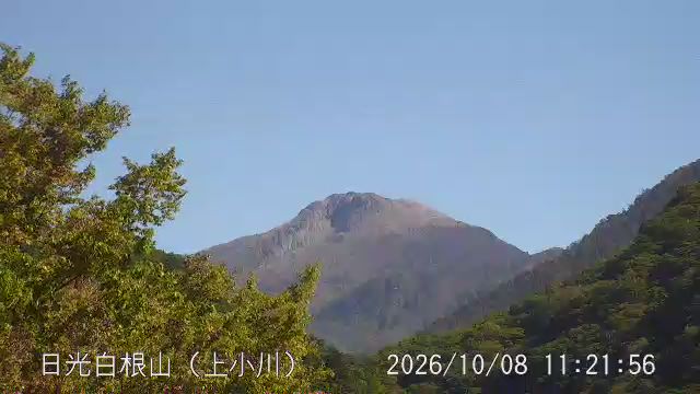
From Kami-Ogawa in Katashina village, Gunma, about ten kilometers west of the summit, this JMA camera looks east toward Nikko-Shiranesan. The mountain rises on the border of Gunma and Tochigi, and from this side you see its western slopes, where thick lava flows run out from beneath the summit dome.
Nikko-Shiranesan, often called Oku-Shirane, is the highest peak in the Kanto region and in northeastern Honshu. JMA describes it as a lava dome about a kilometer across sitting on top of several thick lava flows. Its historical eruptions were steam explosions from the summit, the best documented in 1649, and JMA notes there is no active fumarole area today. A ropeway on the Marunuma Kogen side carries hikers part of the way up, and the peak holds snow from late autumn into early summer.
JMA uses a five-level Volcanic Alert Level for Nikko-Shiranesan: Level 1 notes that it is an active volcano, while Levels 2 and 3 close the area near the crater or the whole mountain, and 4 and 5 deal with evacuation. Look up JMA's current level for the latest.
Camera details
- Camera ID
- 30202
- Operator
- Japan Meteorological Agency (気象庁)
- Volcano
- Nikko-Shiranesan
- Observatory
- Japan Meteorological Agency
- Camera site
- Kami-Ogawa
- Site (local name)
- 日光白根山 上小川
- Image updates
- Every 2 min
- Video format
- Still image (JPEG)
- Position
- Exact (from the provider)
- Licence
- Public Data License (Japan) 1.0
- Data source
- JMA volcano monitoring cameras (Japan)
- Last checked
- Oct 7, 17:15 UTC (10 h ago)
- Working, last 7 days
- 100 % of checks
From the provider's own camera list and our automatic checks. Readings and details can change without notice.
Live camera in Numata, Japan
Weather now in Numata: 19 °C (65 °F), clear sky, wind 8 km/h (5 mph) from the west. Forecast for 12 PM local time. Weather: MET Norway (CC BY 4.0)
Numata is a town in Japan with about 47,000 people. The camera is about 26 km from the center. Saku, the nearest larger town, is 69 km away. Numata keeps Asia/Tokyo time (UTC+9 at the moment); the panel above shows the local time live.
On the map
Live cameras near Numata
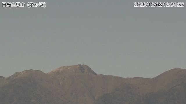
The nearest other cameras are Nikko-Shiranesan volcano camera, Utagahama (22 km).
All Numata live cameras · Camera radar centered here · More from Japan Meteorological Agency
Questions about Nikko-Shiranesan volcano camera, Kami-Ogawa
Can I watch Nikko-Shiranesan volcano camera, Kami-Ogawa live right now?
Yes, it is working: at our last automatic check (Oct 7, 17:15 UTC) it was sending new pictures. It is a still image, not video: a new photo arrives about every 2 minutes straight from Japan Meteorological Agency (気象庁).
How often does this camera refresh?
About every 2 minutes, on Japan Meteorological Agency (気象庁)'s schedule. The image on this page refreshes by itself while the tab is open.
Where does this camera come from?
Japan Meteorological Agency (気象庁) runs this camera, as part of the Japan Meteorological Agency (JMA). It is an official source. Its images are shared under the Public Data License (Japan) 1.0. LiveLocation shows them straight from the source with credit. About Japan Meteorological Agency Watch at the source
Where is the Nikko-Shiranesan volcano camera, Kami-Ogawa camera?
It is about 26 km from the center of Numata, Japan. Coordinates: 36.791, 139.260. All cameras in Numata
What time is it at the camera, and is it day or night?
Numata is in the Asia/Tokyo time zone. The "Right now" panel above shows the local time live. On October 8 the sun rises at 5:43 AM and sets at 5:17 PM there.
Can I see other cameras nearby?
Yes: 1 other camera is within 25 km of this one. The live camera radar shows them all on a map, nearest first. Open the radar here
Where can I check the alert level for this volcano?
The Japan Meteorological Agency sets Japan's Volcanic Alert Levels (1 to 5) and issues the official warnings, not LiveLocation. Check its latest bulletin for this volcano before any trip. Official camera page