Ruapehu South volcano camera webcam — New Zealand
Working, checked 4 h ago Still image · every 10 min Volcano · Official source · What camera types mean
What you are looking at
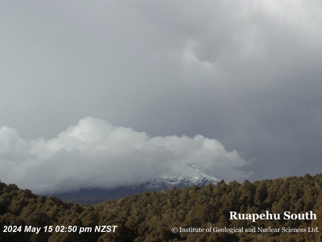
This GeoNet camera looks at Mount Ruapehu from the south. GeoNet is New Zealand's geohazard monitoring service, run by Earth Sciences New Zealand with support from the Natural Hazards Commission, and it keeps cameras on the country's active volcanoes to see eruptions, steam and ash. Ruapehu, the North Island's highest mountain at 2,797 meters, sits at the southern end of Tongariro National Park.
From the south the camera sees the mountain's snowy summit ridges and upper slopes, on the side where the Tūroa ski area lies near Ohakune. The view changes with the seasons and the weather: deep snow and bright, cold mornings in winter, bare grey rock in late summer, and frequent cloud when wet westerly weather crosses the central North Island. Watch the summit area for any unusual steam or dark ash, which volcano scientists would look for too.
The Volcanic Alert Level system in New Zealand runs from 0 (no unrest) through 1 and 2 (minor and moderate to heightened unrest) to 3, 4 and 5 (minor, moderate and major eruption). GeoNet publishes the current level and any bulletins. The camera produces a still image about every 10 minutes, and dark night frames are normal.
Camera details
- Camera ID
- ruapehusouth
- Operator
- GeoNet
- Image updates
- Every 10 min
- Video format
- Still image (JPEG)
- Position
- Approximate
- Licence
- Creative Commons Attribution 3.0 New Zealand
- Data source
- GeoNet volcano cameras (New Zealand)
- Last checked
- Oct 7, 23:00 UTC (4 h ago)
- Working, last 7 days
- 75 % of checks
From the provider's own camera list and our automatic checks. Readings and details can change without notice.
On the map
The position is approximate.
Nearby live views
 WorkingStill imageRuapehu North volcano camera
 WorkingStill imageRuapehu East volcano camera
 WorkingStill imageNgauruhoe volcano camera
 WorkingStill imageSH1 Desert Rd, Waikato
 WorkingStill imageSH1 Waihohonu Bridge, Waikato
 WorkingStill imageNgauruhoe and Tongariro volcano camera
Closest to this one: Ruapehu North volcano camera (0.0 km), Ruapehu East volcano camera (0.0 km) and Ngauruhoe volcano camera (15 km).
Questions about Ruapehu South volcano camera
Is Ruapehu South volcano camera working right now?
Yes, it is working: at our last automatic check (Oct 7, 23:00 UTC) it was sending new pictures. It is a still image, not video: a new photo arrives about every 10 minutes straight from GeoNet.
How often does this camera refresh?
About every 10 minutes, on GeoNet's schedule. The image on this page refreshes by itself while the tab is open.
Where does this camera come from?
GeoNet (Earth Sciences New Zealand with the Natural Hazards Commission Toka Tū Ake) runs this camera. It is an official source. Its images are shared under Creative Commons Attribution 3.0 New Zealand. LiveLocation shows them straight from the source with credit. About GeoNet Watch at the source
Where is the Ruapehu South volcano camera camera?
It is in New Zealand. Approximate coordinates: -39.28, 175.57.
Is it day or night there now?
The camera is in the Pacific/Auckland time zone. The "Right now" panel above shows the local time live. On October 8 the sun rises at 6:43 AM and sets at 7:27 PM there.
Can I see other cameras nearby?
Yes: 9 other cameras are within 25 km of this one. The live camera radar shows them all on a map, nearest first. Open the radar here
Where can I check the alert level for this volcano?
GeoNet sets New Zealand's Volcanic Alert Levels (0 to 5) for this volcano, not LiveLocation. Check its latest volcanic activity bulletin before any trip. GeoNet volcano alerts Official camera page