Mount St. Helens live webcam – Mount St. Helens from Johnston Ridge Observatory
Working, checked 15 h ago Still image · every 5 min Volcano · Official source · What camera types mean
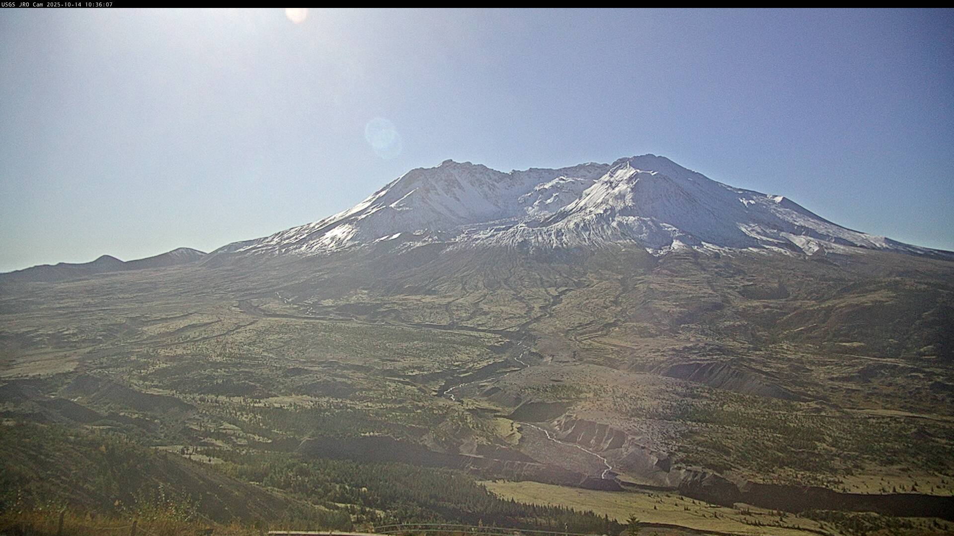
What you are looking at
This is the USGS Cascades Volcano Observatory camera at Johnston Ridge Observatory, about 9 km (6 miles) north of Mount St. Helens in southwest Washington. It looks south straight into the open horseshoe of the crater that the volcano blew out on May 18, 1980, with the lava domes on the crater floor, the crater walls on either side, and the Pumice Plain spreading below toward Spirit Lake and the North Fork Toutle River.
The 1980 eruption began with a huge landslide and sideways blast that flattened forests across this ridge. Lava domes then grew in the crater in the 1980s and again from 2004 to 2008, and a new glacier has formed around them. Mount St. Helens remains the most active volcano in the Cascades, so check the CVO page for its current alert level and weekly updates.
The snapshot updates about every five minutes. Clear mornings show the dome and the steaming spots on it best; summer afternoons can be hazy, and winter brings snow, low cloud and short days. Night frames are dark. Tip: the road to Johnston Ridge was cut by a landslide in 2023, so check the US Forest Service for current access before planning a drive.
Camera details
- Camera ID
- JRO
- Operator
- USGS Cascades Volcano Observatory
- Volcano
- Mount St. Helens
- Volcano number (Smithsonian GVP)
- 321050
- Camera faces
- South (164°)
- Image updates
- Every 5 min
- Video format
- Still image (JPEG)
- Position
- Approximate
- Licence
- U.S. public domain
- Data source
- USGS volcano webcams
- Last checked
- Oct 7, 12:15 UTC (15 h ago)
- Working, last 7 days
- 100 % of checks
From the provider's own camera list and our automatic checks. Readings and details can change without notice.
About Mount St. Helens, Washington
Weather now in Mount St. Helens: 57 °F (14 °C), clear sky, wind 4 mph (6 km/h) from the east. Forecast for 8 PM local time. Weather: MET Norway (CC BY 4.0)
Mount St. Helens is a place in Washington, United States. The camera is about 5.9 mi from the center. Mount St. Helens keeps America/Los Angeles time (UTC−7 at the moment); the panel above shows the local time live.
Mount St. Helens rises in Skamania County in southwest Washington, about 52 miles northeast of Portland and close to 100 miles south of Seattle. It is the most active volcano in the Cascade Range in modern times. On the morning of May 18, 1980, an earthquake set off the collapse of its bulging north face, the largest landslide in recorded history, and a sideways blast and eruption followed. Fifty-seven people…
On the map
The position is approximate.
Live cameras near Mount St. Helens
 WorkingStill imageMount St. Helens: St. Helens (JRO, Dome)
 WorkingStill imageSt. Helens (JRO, East Wall)
 WorkingStill imageMount St. Helens: St. Helens (JRO, Glacier)
 WorkingStill imageMount St. Helens: St. Helens (JRO, Loowit Fan)
 WorkingStill imageMount St. Helens: St. Helens (JRO, NF100)
 WorkingStill imageMount St. Helens: St. Helens (JRO, Spirit Lake Blockage)
Closest to this one: Mount St. Helens: St. Helens (JRO, Dome) (0.0 mi), St. Helens (JRO, East Wall) (0.0 mi) and Mount St. Helens: St. Helens (JRO, Glacier) (0.0 mi).
All Mount St. Helens live cameras · Camera radar centered here · More from USGS volcano observatories
Questions about Mount St. Helens from Johnston Ridge Observatory
Is the Mount St. Helens from Johnston Ridge Observatory camera live right now?
Yes, it is working: at our last automatic check (Oct 7, 12:15 UTC) it was sending new pictures. It is a still image, not video: a new photo arrives about every 5 minutes straight from USGS Cascades Volcano Observatory.
Who runs this camera?
USGS Cascades Volcano Observatory runs this camera, as part of the U.S. Geological Survey (USGS) Volcano Hazards Program. It is an official source. Its images are in the U.S. public domain. LiveLocation shows them straight from the source with credit. About USGS volcano observatories Watch at the source
Where is the Mount St. Helens from Johnston Ridge Observatory camera?
It is about 5.9 mi from the center of Mount St. Helens, Washington, United States. Approximate coordinates: 46.28, -122.22. All cameras in Mount St. Helens
What time is it at the camera, and is it day or night?
Mount St. Helens is in the America/Los Angeles time zone. The "Right now" panel above shows the local time live. On October 7 the sun rises at 7:15 AM and sets at 6:37 PM there.
Can I see other cameras nearby?
Yes: 16 other cameras are within 25 miles of this one. The live camera radar shows them all on a map, nearest first. Open the radar here
Where can I check the alert level for this volcano?
USGS Cascades Volcano Observatory sets the U.S. Volcano Alert Level and Aviation Color Code for this volcano, not LiveLocation. Read its latest update before you plan a visit; the camera alone cannot tell you how safe it is. USGS volcano updates Official camera page
What do the sensors at Mount St. Helens from Johnston Ridge Observatory show?
The latest readings from the provider: Volcano alert level: NORMAL · aviation code GREEN; Last USGS notice: Sep 16, 2025, 10:42 local time; Issued by: Cascades Volcano Observatory (USGS). They update with the provider's data, so they can be a few minutes old.